Flood Awareness
Did you know?
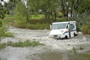
Many people think that if they do not live near a stream or creek they are not in danger of flooding; this is not true. Flooding is the nation’s number one natural disaster. Flash floods, inland flooding and seasonal storms flood every region of the country. Flood maps don’t show all areas at risk! Flooding can and often does occur outside the mapped floodplain. Flooding often occurs along smaller streams and creeks that are not shown on any flood maps. Non-creek flooding can occur from overwhelmed storm sewers, low-lying areas that do not have proper drainage, or water mains that break. Much of the true risk of flooding is its unpredictability.
Colorado’s flood season, which is historically from May through October, includes both snowmelt and thunderstorm flooding. Snowmelt floods result from the melting of the winter snowpack in the high mountain areas which becomes spring runoff. Thunderstorm floods are caused by intense rain over relatively small areas. Because there is little to no warning time, the term flash flood is often used to describe thunderstorm floods. Between 20 and 30 large floods occur somewhere in Colorado every year and Colorado experiences a major flood disaster roughly once every five years.
You can reduce your risk of flooding by being prepared and knowing how to respond when there is a flood. Visit our pages about Flood Safety, Flood Recovery, and Flood Insurance to learn more about how to be prepared before a flood, how to develop an Emergency Plan, and what to do during a flood.
MHFD Real-Time Alert System Interface – stay in the loop. The Mile High Flood District (MHFD) works with local governments to address multi-jurisdictional drainage and flood control challenges in order to protect people, property, and the environment. From this link you are able to review rainfall-related and weather activity throughout the Denver metro region.